


Fogo - The Fire Island in Detail.
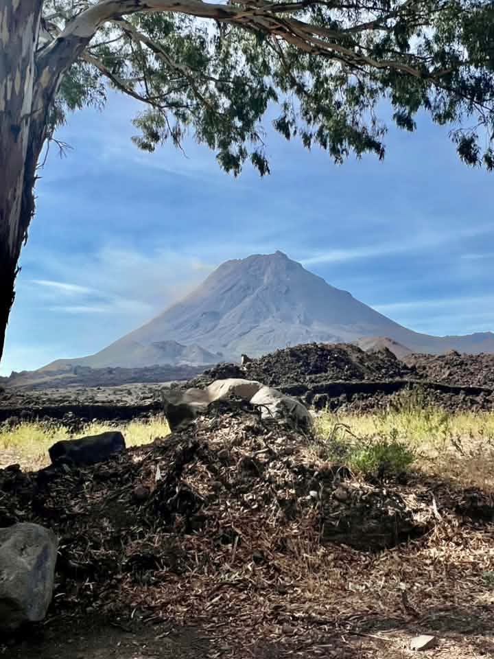
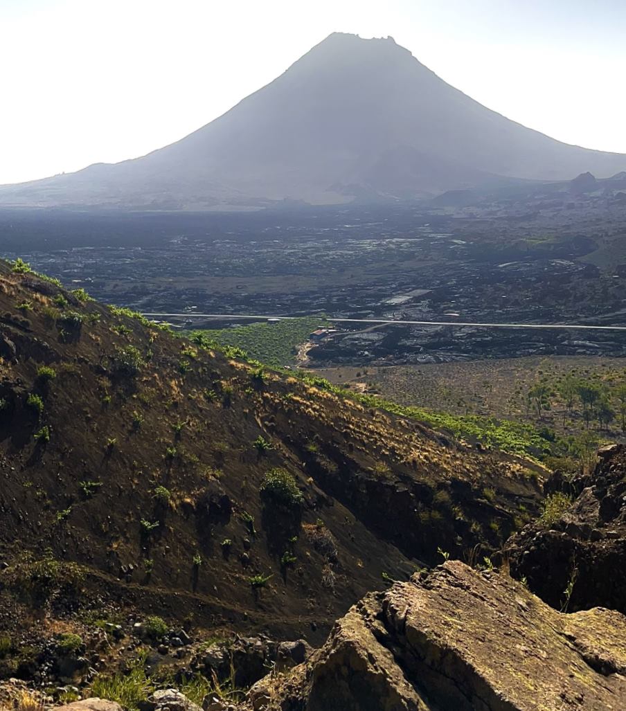
Fogo holds Cape Verde's highest point: the active volcano Pico do Fogo, 2,829 m high, last erupted in 2014/15. Stand inside the Chã das Caldeiras crater and you'll see vines growing straight out of cooled lava, and a village that was simply rebuilt after lava destroyed it. Since 2020, the whole island has been a UNESCO Biosphere Reserve. Here's everything you actually need to plan a visit - no marketing fluff.
Fogo in 60 Seconds.
Fogo is one of Cape Verde's most volcanically active and dramatic landscapes: a 2,829 m, still-active volcano, a roughly 8 km wide caldera with vineyards grown without any artificial irrigation, and the historic sobrado mansions of São Filipe. If you're after volcano hiking, wine and real geology, this is exactly the right island - for classic beach holidays, Sal or Boa Vista are a much better fit.
Fogo at a Glance.
- Location
- Sotavento group, south of Santiago, east of Brava
- Area
- ca. 476 km²
- Main town
- São Filipe (administrative seat & airport)
- Airport
- Aeródromo de São Filipe (SFL) - domestic flights only, short, wind-exposed runway
- Population
- ✓ Verified
33,519 (2021 Census, INE) - down from around 35,800 (2015), partly due to emigration - Highest point
- Pico do Fogo, 2,829 m - active volcano, the highest point in Cape Verde (West Africa's highest mountain is Mount Cameroon at ca. 4,040 m)
- Administration
- Three municipalities: São Filipe, Santa Catarina do Fogo, Mosteiros
- Language
- Portuguese (official) · Kriolu (everyday)
- Currency
- Cape Verdean Escudo (CVE), fixed to the euro: 1 € = 110.265 CVE
- Time zone
- UTC-1 (no daylight saving in Cape Verde)
- Power
- 220-230 V, plug types C/F
- Tourist tax
- 276 CVE (ca. €2.50) per person & night from age 16, capped at 10 nights
Who Is Fogo Right For?
Fogo is the most volcanic and culturally dense island in Cape Verde - but not a beach destination. An honest look before you book.
Great for...
- Volcano hikers who want to climb Cape Verde's highest mountain (2,829 m) with a guide
- Wine lovers - vineyards grown straight into the crater, with no artificial irrigation, carrying a protected designation of origin since 2021
- Geology and nature fans - active fumaroles, lava flows, UNESCO Biosphere Reserve since 2020
- Those interested in cultural history - the sobrado mansions of São Filipe tell the story of Cape Verdean trade history
- Travelers with a time buffer who value an authentic, less touristy experience
Less suited for...
- Beach holidaymakers - the coastline is black volcanic rock, and several beaches are considered dangerous due to strong undercurrents
- Travelers with a fear of heights or limited fitness - the volcano ascent is demanding and only permitted with a guide
- Anyone expecting serious medical care on-site - the island hospital's surgical capacity is limited
- Travelers without a time buffer - Bruma Seca dust haze and rough seas can ground flights and ferries for days
When's the Best Time to Visit?
Like the other Cape Verde islands, Fogo has an arid coastal climate - but with an altitude contrast no other island offers.
On the coast around São Filipe, temperatures stay mild year-round at around 22°C on average. In the crater caldera of Chã das Caldeiras, at 1,700 m, winter nights can drop close to freezing by contrast - a contrast you won't find on any other Cape Verde island. November to June is considered the best time for the volcano climb.
Bruma Seca Can Ground Flights
Between December and March, Saharan dust haze ("Bruma Seca") can limit visibility so badly that the small São Filipe airport is sometimes cut off from air traffic entirely. If you're traveling during this period, build in a time buffer and keep the ferry in mind as a fallback if possible.
A village that lives inside the crater of an active volcano - Fogo shows Cape Verde at its most dramatic.
Pico do Fogo in Detail.
Cape Verde's highest mountain is also its most active volcano - and that shapes every encounter with it.
Summit Only With a Guide
Climbing the 2,829 m Pico do Fogo is only allowed with licensed local guides - partly because an active fumarole field sits in the summit crater (about 500 m wide, 150 m deep), with gas vents reaching temperatures between roughly 95°C and up to 400°C depending on the measuring spot. The ascent takes around 4 hours; the descent through fine lapilli ash fields often takes only 30 to 45 minutes at a sliding jog.
Pico Pequeno - the Real Danger Source
The destructive eruptions of 1995 and 2014/15 didn't come from the main summit crater, but from Pico Pequeno and nearby fissures at the base of the cone. In 2014/15, the eruption began on 23 November 2014 at a fissure on the western flank and ended on 8 February 2015 - with lava flows, Strombolian activity and ash emissions along the entire fissure.
The Bordeira Caldera
The massive Bordeira caldera rim encloses a caldera that, according to the UNESCO tentative list, is roughly 8 km wide, open to the east, with a wall up to 1 km high. It's the scarp of a gigantic flank collapse around 73,000 years ago, which triggered a mega-tsunami 170 m high that reached Santiago, 55 km away - one of the largest known tsunami sources in Earth's history.
Rebuilding Despite a Building Ban
After the 2014/15 eruption, the government issued a building ban in the destroyed high-risk zone. Many residents ignored it and rebuilt houses, guesthouses and vineyards right on top of the still-warm lava - an expression of the Chã community's special bond with their volcano, but also a sign that lava-flow risk in these zones is still rated high.
12 Eruptions Since 1500
The Smithsonian Global Volcanism Program lists 12 confirmed historical eruptive periods for Pico do Fogo since the year 1500 - roughly one active phase every two years on average, though the true frequency is likely underestimated due to gaps in the historical record. That makes Fogo one of the most active volcanoes in the entire Atlantic.
That's how high the mega-tsunami was, triggered by a gigantic flank collapse of the Fogo volcano around 73,000 years ago - the waves reached Santiago, 55 km away, and it's considered one of the largest known tsunami sources in Earth's history.
Fogo Is Also a Biosphere Story.
A UNESCO Biosphere Reserve since 2020, with a protected designation of origin for its wine since 2021 - Fogo is more than just the volcano.
UNESCO Biosphere Reserve
Since 28 October 2020, all of Fogo has been a UNESCO Biosphere Reserve - the same day Maio was designated as Cape Verde's second, separate biosphere reserve. Fogo's own reserve covers roughly 102,142 ha of land and sea (ca. 47,074 ha land, 55,068 ha sea). Its core is the Parque Natural do Fogo at about 8,469 ha, split across the municipalities of Santa Catarina do Fogo (50%), Mosteiros (28%) and São Filipe (22%). The natural park itself remains only on UNESCO's tentative list, not its World Heritage list.
Endemic Species
The biosphere reserve is home to rare Cape Verde-endemic reptiles such as the López-Jurado half-toed gecko (Hemidactylus lopezjuradoi) and Vaillant's skink (Chioninia vaillantii), listed as endangered. Particularly sensitive endemic plants concentrate mainly in Bordeira and Chã das Caldeiras.
Wine Without Irrigation
Vineyards concentrate on plots between 1,500 and 2,000 m in Chã das Caldeiras - entirely without artificial irrigation, since the porous volcanic rock stores overnight dew and rainwater is collected in cisterns for the dry season (November to July). The Preta Tradicional grape variety defines the region's reds and rosés. In 2021, the producer cooperative's Vinho do Fogo received a protected designation of origin (Denominação de Origem).
Coffee in the Fog Forest of Mosteiros
Unlike the dry crater, Fogo's organic Arabica coffee thrives on the damp slopes of Mosteiros municipality, between roughly 350 and 1,300 m - grown entirely without synthetic fertilizer or pesticides, fed purely by rainwater. Coffee cultivation was introduced here as far back as the 18th century and remains a rare, small-batch quality product today.
Manecom Isn't a Strong Drink
◐ Community valueAlongside the certified Vinho do Fogo, families in Chã das Caldeiras traditionally also brew Manecom - a semi-sweet to dry, low-alcohol house wine made from the Malvasia Branca and Forasteira grapes, drunk as an aperitif or digestif. Unlike what's sometimes claimed, Manecom is not a high-proof drink but a mild, informal family product.
That's how many people live in Chã das Caldeiras - right inside the crater of an active volcano, with no piped water (just cisterns), but since 2024 with its own solar microgrid, independent of the island's power network.
Four Towns, Four Faces.
From the colonial seaside town to the village inside the volcano crater - Fogo's three municipalities look very different from one another.
São Filipe
The island's administrative seat on the west coast, defined by its historic sobrados - two-storey colonial mansions from the 19th century. The upper class lived upstairs in the ventilated floor, while enslaved people once worked in the windowless ground floor. The fine pitch-pine wood of many sobrados came from American whaling ships, which brought it as ballast in the 18th/19th centuries.
Chã das Caldeiras
The settlements of Portela and Bangaeira sit right inside the Bordeira caldera, surrounded by vineyards and the lava flows of the 1995 and 2014/15 eruptions. The starting point for the summit climb and for wine tastings at the producer cooperative - bring cash, there are no ATMs.
Mosteiros
The northeastern municipality with the island's dampest, foggiest slopes - this is where Fogo's Arabica coffee grows. The municipality is also known for Sodade wine from Achada Grande as well as fruit liqueurs and brandies: economically, Fogo is clearly more than just the volcano and the Pico.
Santa Catarina do Fogo
The smallest of the three municipalities on the island's eastern flank, noticeably more rural and less developed for tourism than São Filipe. Part of the Parque Natural do Fogo lies within its territory - historic 18th/19th-century lava flows reached the coast here several times.
What to Experience on Fogo.
Climbing Pico do Fogo
The signature activity: around 4 hours up to the summit crater, then 30 to 45 minutes of sliding descent through lapilli ash fields. Only with a certified local guide; sturdy shoes and enough water are mandatory.
Wine Tasting in Chã das Caldeiras
Tasting Vinho do Fogo right at the producer cooperative, whose adega was completely destroyed by the 2014 eruption and later rebuilt with makeshift infrastructure - tasting wine among lava rock, quite literally.
Walking the Sobrados of São Filipe
Stroll the historic old town with its colorful two-storey colonial mansions - a window into 19th-century Cape Verdean trade and colonial history.
Swimming at Ponta da Salina
Natural basalt rings break the waves here, creating the safest open-water swimming spot on Fogo - unlike the dangerous local beach Fonte Bila in São Filipe, where swimming is advised against due to strong undercurrents.
Coffee Tour in Mosteiros
Visit the coffee plantations on the island's foggy northeastern slopes, between 350 and 1,300 m - a contrast program to the dry volcano crater, often paired with a tasting.
Experience Festa da Bandeira (Late April/May 1)
The Cavalhadas horse races on the sand-covered cobblestone streets of Alto de São Pedro are the heart of this festival - combined with a procession, a market fair and the trance-like Pilão corn-pounding ritual for the traditional dish Xerém. Demand is huge, so book months ahead.
Guide Certification Is Mandatory, Not Optional
The profession of "Guia de Turismo" is subject to a legal professional-card requirement in Cape Verde (introduced in 2021, tightened by Decreto-Lei 49/2025 of 22 December 2025 - though that decree doesn't formally take effect until 23 June 2026). For the Pico do Fogo climb, that means in practice: only certified, locally knowledgeable guides know the current fumarole and hazard situation - going it alone isn't just unwise, it's barely possible in practice.
How Much Time to Plan for Fogo?
Three example rhythms for orientation - not a rigid plan, but a template to adapt.
Volcano Focus
- Day 1: Arrival, settle in at São Filipe, sobrados walk
- Day 2: Transfer to Chã das Caldeiras, Pico do Fogo climb with guide
- Day 3: Wine tasting in Chã das Caldeiras, return transfer, departure
Volcano & Culture
- Day 1-2: São Filipe, sobrados, swimming at Ponta da Salina
- Day 3: Transfer to Chã das Caldeiras, acclimatization
- Day 4: Pico do Fogo climb with guide, wine tasting in the evening
- Day 5: Coffee tour in Mosteiros, return transfer, departure
Combine With Island Hopping
- Week 1: as above - explore Fogo at a relaxed pace
- Add-on: Brava is just a short ferry ride away and pairs well, since both islands share the same CV-Interilhas route
How Do You Get to Fogo?
From Praia or Sal
⚠ Subject to changeAeródromo de São Filipe (SFL) is served exclusively by domestic flights - there's no direct connection from outside Cape Verde. Since 29 March 2026, the new state inter-island carrier CVsky has operated this route with its ATR 72-600 fleet; the short, wind-exposed runway only allows small turboprop aircraft in any case. Between December and March, Saharan dust haze (Bruma Seca) can disrupt flights for days at a time.
From Praia (Santiago)
CV Interilhas connects Praia and São Filipe with a regular ferry; the crossing takes around 4 hours and is considered one of the roughest routes in Cape Verde due to the open Atlantic swell. The ferry port of Vale dos Cavaleiros sits unprotected in the swell - in rough conditions the ferry can sometimes be unable to dock there at all. CV Interilhas also carries vehicles on this route.
Arriving & Getting Around.
What to specifically watch out for on Fogo - especially inside the caldera.
Plan for Cash in the Caldera
There are no ATMs or card terminals anywhere in Chã das Caldeiras - your entire budget for accommodation, wine and food has to be brought in as cash from São Filipe.
Aluguer Schedules Are Rigid
Shared taxis (Aluguer) between São Filipe and Chã das Caldeiras don't run continuously - departures up to the caldera tend to bunch up in the early morning (around 6 am). If you want flexibility, book a private tour or rent a car.
SIM Card & Network
Alou and Unitel T+ both have coverage on Fogo too. Expect a weaker signal in the deeply cut caldera and on the steep slopes of Mosteiros than on the coast around São Filipe.
Entry Requirements
Travelers from the EU, UK, US and Canada can enter visa-free for stays up to 30 days; most other nationalities, including Australia, get a visa on arrival. The paid EASE online registration plus airport tax (TSA) applies at your international port of entry (Praia or Sal) - there's no separate second check when continuing on to Fogo by domestic flight or ferry.
Pack Warm Layers for Caldera Nights
If you're staying overnight in Chã das Caldeiras, pack warm clothing despite the mild coastal temperatures - nights at 1,700 m can get noticeably cold, close to freezing in winter months. A classic packing mistake is relying only on the coastal figures of around 22°C.
What You Should Watch Out For.
General Safety
Fogo is considered a comparatively safe island, usually rated similarly to the other Cape Verde islands in travel advisories. Ordinary caution is enough: don't leave valuables unattended, only go on the volcano with a guide, don't swim at dangerous beaches (including Fonte Bila). Check your own country's current travel advisories before departure.
Medical Care
Hospital Regional São Francisco de Assis in São Filipe serves Fogo and Brava together, but does not perform complex operations - surgical capacity is repeatedly limited, and serious cases are transferred to Praia. Night-time air evacuations are additionally risky, since São Filipe airport isn't lit. International health insurance with genuine repatriation cover is therefore not an extra, but the core of your protection - especially for volcano climbers.
Health & Vaccinations
The usual travel vaccinations (including tetanus/diphtheria, hepatitis A) are recommended - consult a doctor before your trip. Cape Verde has been officially malaria-free since January 2024. In 2023/2024 there was a nationwide dengue outbreak (around 19,000 cases, 8 deaths, declared over in January 2025): in the early phase, Fogo was the hardest-hit island, but as the year went on the focus shifted clearly to the capital Praia on Santiago - treat this as general, nationwide Cape Verde information, but don't take it lightly on Fogo either.
Emergency Numbers
Police 132 · Fire Brigade 131 · Ambulance 130. According to several international travel sources, these are also reachable without a SIM card (we couldn't find an official confirmation that calls are free of charge) - save them to your phone right on arrival, especially before the volcano climb.
Where to Stay?
Deliberately without invented individual prices: prices change constantly by season and provider. These three categories help you get oriented.
Budget
Simple guesthouses- Mostly in São Filipe, off the main road
- Simple rooms, often family-run
- Good base for day trips to the volcano
Mid-range
Hotels & guesthouses- Central in São Filipe or right in Chã das Caldeiras
- Staying in the caldera is recommended for an early summit start
- Some with views of Pico do Fogo
Boutique
Upscale small properties- A handful of high-quality addresses in São Filipe
- No large all-inclusive resorts like on Sal or Boa Vista
- Focus on location, views and quiet rather than full board
If you want to climb the volcano early in the morning, it's best to stay directly in Chã das Caldeiras rather than São Filipe - that saves the early drive up. Check current availability directly with each provider.
What Does a Week on Fogo Cost?
€ Price guideBallpark figures per person and week on the ground (excluding getting there), highly dependent on season and style - for rough orientation, not an exact quote.
| Category | Budget | Mid-range | Comfortable |
|---|---|---|---|
| Accommodation | Simple guesthouse | Hotel/guesthouse, central | Boutique address |
| Food | Local cuisine, simple restaurants | Mix of restaurants & wine tasting | Upscale restaurants, several wine tastings |
| Local transport | Aluguer on its schedule | Taxi & organized tours | Private driver / rental car throughout |
| Activities | Swimming, sobrados walk | Summit climb with guide | Guide + wine tastings + coffee tour |
Planning More Than Just a Visit?
Volcano hiking, wine enjoyment or real estate interest - three topics that go beyond a simple short visit.
Volcano Hiking on Fogo
From the guide requirement to the right gear for the ascent and ash-field descent - our tours guide shows what matters for the Pico do Fogo climb.
Tours & Activities →Wine & Coffee From the Volcano
Vinho do Fogo with a protected designation of origin since 2021, plus rare Arabica coffee from Mosteiros - Fogo is culinarily more than a footnote in Cape Verde.
Cape Verdean Cuisine →Buying Property on Fogo
As everywhere in Cape Verde, a tax number (NIF) and a notarized preliminary contract are mandatory. An important Fogo-specific point: plots in volcanic risk zones (including parts of Chã das Caldeiras) deserve special legal and geological scrutiny before purchase.
Available soon (EN)What Actually Helps on Fogo.
Not a generic travel packing list, but what makes a real difference specifically on Fogo.
- Sturdy, closed hiking boots with good grip - essential for lava and lapilli terrain
- A warm layer for overnight stays in Chã das Caldeiras - near freezing at night in winter
- Enough cash in escudos for the whole caldera stay - no ATMs on site
- Sun protection, a hat and enough water for the summit climb
- A time buffer in your itinerary during Bruma Seca season (December to March)
- A travel first-aid kit and international health insurance with genuine repatriation cover
- Early booking of guide tour and accommodation if your trip falls around Festa da Bandeira (late April/May 1)
Sources & Page Status
- Emergency number fee-free status clarified: as with other pages on this site, we couldn't find an explicit official confirmation that calls to 132/131/130 are free of charge, so we added the independently confirmed fact that the numbers are reachable even without a SIM card instead.
- Fogo population (33,519): official 2021 Census from INE Cabo Verde - primary source. A previously cited UN News article (May 2024) stated a differing "approx. 48,700" but did not itself cite a primary source; that figure was removed and replaced with the official census figure. The decline from "around 35,800 (2015)" is plausible and consistent with Fogo's known, partly emigration-driven population trend.
- UNESCO Biosphere Reserve (clarified 24 Oct 2026, since 28 Oct 2020, 102,142 ha): confirmed via the official UNESCO MAB Programme page on Fogo - primary source, additionally cross-checked by adding the official sub-areas (47,074 ha land + 55,068 ha sea = 102,142 ha). Clarified: the 102,142 ha is Fogo's own reserve area, not combined with Maio - Maio has its own, separate biosphere reserve of roughly 74,000 ha. A different, circulating zone breakdown (core/buffer/transition: 6,919 + 15,031.3 + 50,191.7 ha) sums to only 72,142 ha and likely stems from a digit transposition in a secondary source - for the total area, we kept the figure independently confirmed by the land+sea split (102,142 ha).
- 2014/15 eruption (23 Nov 2014 - 8 Feb 2015) & 12 eruptions since 1500: data from the Smithsonian Global Volcanism Program and a GFDRR Post-Disaster Needs Assessment report - both cross-checked directly.
- Fumarole temperature (clarified 24 Oct 2026): the previously cited single reading "up to 354°C" could not be found in the scientific literature (including Frontiers in Earth Science, Aiuppa et al.), which instead describes a low-temperature fumarole (~95-100°C) and a medium-temperature fumarole (~300°C), with peak values up to roughly 400°C. Body text adjusted to this better-documented range (95-400°C).
- Bordeira mega-tsunami (corrected 24 Oct 2026, ca. 73,000 years ago, Santiago 55 km away): based on Ramalho et al. 2015, Science Advances. Clarification: the study gives two different figures for the same event, not two competing studies - "170 m" is the authors' calculated minimum incoming wave height at the then-shoreline, while the documented run-up height further inland exceeded 270 m. Both numbers come from the same original study, not from later, diverging analyses. This page still cites "170 m" as the figure most commonly used in media and secondary sources.
- CVsky flight operations since 29 March 2026 with ATR 72-600: confirmed via the official CVsky press release as well as independent aviation news outlets. Cape Verde has also been officially WHO-certified malaria-free since 12 January 2024.
- Dengue distribution clarified: the figure originally cited here, "Fogo ~59%, Santiago ~37%," reflects the situation as of June 2024 per IFRC/ReliefWeb reports and was only a snapshot of the early outbreak phase. Later situation reports showed a clear shift toward the capital Praia: by 15 October 2024, 6,014 of 8,152 confirmed cases (73.8%) were already in Praia alone (expressodasilhas.cv). The epidemic was declared over in January 2025 with roughly 19,000 total cases and 8 deaths (observador.pt, 10 March 2025). Body text updated accordingly.
- Caldera width (corrected from 9 km to 8 km): the official UNESCO tentative-list description "Parc Naturel de Fogo - Chã das Caldeiras" explicitly states "8 km in diameter" - a previous version of this page cited 9 km from a less authoritative secondary source.
- Highest point (corrected): Pico do Fogo is Cape Verde's highest point, not West Africa's - Mount Cameroon (ca. 4,040 m) is West Africa's highest mountain. An earlier version of this page incorrectly claimed both for Pico do Fogo.
How Our Members See It.
Questions About Fogo.
Do you have to climb Pico do Fogo with a guide?
Yes. The summit climb is only allowed with certified local guides - partly because of an active fumarole field at the summit crater, which can reach temperatures above 200°C.
Is the volcano currently dangerous for visitors?
Pico do Fogo is an active volcano with 12 documented eruptions since 1500, most recently in 2014/15. The standard guided climb is considered safe, but the hazard situation can change - which is why a certified guide is mandatory, and going alone is not allowed.
Are there sandy beaches on Fogo?
Barely. The coastline is mostly black volcanic rock, and several beaches like Fonte Bila in São Filipe are considered unsuitable for swimming due to dangerous undercurrents. Ponta da Salina offers a safer alternative in natural basalt pools.
How do you get to Fogo?
By domestic flight to Aeródromo de São Filipe (SFL) from Praia or Sal, or by ferry from Praia (around 4 hours, weather-dependent). There's no direct connection from outside Cape Verde.
Do you need cash in Chã das Caldeiras?
Yes, absolutely. There are no ATMs or card terminals anywhere in the volcano caldera - your budget has to be brought in as cash from São Filipe.
How many days should you plan for Fogo?
3 days is enough for the volcano climb and São Filipe; for a more relaxed program with wine tasting and a coffee tour, plan for 5 days or more.
Is Fogo wine really grown without artificial irrigation?
Yes - the porous volcanic rock stores overnight dew, and rainwater is additionally collected in cisterns for the dry season. Since 2021, Vinho do Fogo has carried a protected designation of origin.
Is Fogo a UNESCO World Heritage Site?
Not quite - the island has been a UNESCO Biosphere Reserve since 28 October 2020 (together with Maio). The Parque Natural do Fogo itself is only on UNESCO's tentative list, not its World Heritage list.
Is it worth combining Fogo with Brava?
Yes - Fogo and Brava are connected by the same CV-Interilhas route, the crossing takes only around 50 to 60 minutes and pairs well.
Do I have to pay a tourist tax?
Yes - the state Taxa de Turismo is 276 CVE (ca. €2.50) per person and night from age 16, capped at a maximum of 10 nights per stay.
How to Plan Fogo - Step by Step.
Three steps from idea to booked trip - focused on the two things that really matter on Fogo: guide and time buffer.
Sort Out Guide & Travel Dates
No certified guide means no summit climb - sort that out early, and if possible plan your trip outside Bruma Seca season (December to March).
To Volcano & Hiking →Compare Flights, Ferry & Accommodation
Current prices for Fogo all in one place - the bar at the bottom of the screen stays visible as you scroll, so you can compare anytime.
Get the Insider Knowledge
Emergency numbers, community experiences, and the 360° Check for an honest read on whether a volcanic island is really right for you - before you commit.
Start the 360° Check →Ready for Fogo?
Compare current prices for flights, ferries and accommodation, or take a look at the other 8 islands first before deciding.